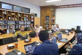
Yogyakarta, 25 September 2025 – The Collaborative Regional Research Programme–Asia Pacific Network for Global Change Research (CRRP–APN) Team from the Department of Agricultural and Biosystems Engineering (DTPB), Faculty of Agricultural Technology, Universitas Gadjah Mada (FTP UGM), organized a training program entitled “Training Application of Machine Learning and GIS for Future Land Use Projection.” The event took place in Room 384, FTP UGM, attended by students of DTPB UGM as well as the general public.
The training was opened by Dr. Ngadisih, who delivered the welcoming remarks and emphasized the importance of mastering spatial technology to address future challenges in climate change and land management. The main sessions were then led by Isnaini Dairina, M.Sc., along with other teaching staff.

During the training, participants received technical knowledge on the use of machine learning and geographic information system (GIS)-based software, such as Google Earth Engine, ArcGIS Pro, and QGIS (MOLUSCE Plugin). Using these applications, participants were trained to process satellite imagery data to develop land use maps and project future land use scenarios. This approach is expected to provide more comprehensive insights for spatial planning, environmental risk mitigation, and the promotion of sustainable development.
This activity is closely aligned with several Sustainable Development Goals (SDGs), including:
-
SDG 4 (Quality Education): providing learning opportunities and capacity building for students and the public,
-
SDG 9 (Industry, Innovation, and Infrastructure): encouraging the use of geospatial and machine learning technologies for land use planning,
-
SDG 13 (Climate Action): supporting adaptation and mitigation efforts to address the impacts of climate change through more accurate land use projections,
-
SDG 15 (Life on Land): contributing to ecosystem sustainability through environmentally balanced land use planning.
Through this training, DTPB FTP UGM hopes participants will gain not only theoretical understanding but also practical skills that can be directly applied in research, spatial planning, and community service.